Water resources in the East of England are experiencing pressures arising from over-abstraction for both domestic and irrigation water supplies that threaten the ecology of chalk streams that are unique to the region. One strategy to support chalk streams is to employ nature-based solutions (NbS) to increase water availability, improve groundwater recharge and enhance river baseflows. In 2024, the Environment Agency and Water Resource East commissioned a project for the design, installation and monitoring of a runoff attenuation feature (RAF) in the River Wensum catchment, Norfolk, contributing evidence on the benefits of NbS. The Wensum is a case study catchment in the FARMWISE project.
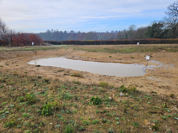
A suitable site for RAF construction was identified in Autumn 2024 in the Wendling Beck sub-catchment where low permeability glacial deposits overlie higher permeability sands and gravels, providing the potential to generate both surface runoff and infiltration to groundwater. In Spring 2025, a RAF was designed by Rivers Ecology that maximised surface runoff interception while having a naturalistic pond appearance (Figure 1). A sump at the southern end of the feature, about 2.5 m below ground level, was constructed to direct surface runoff into a smaller area to increase the hydraulic head and thereby enhance infiltration. Construction took place over 11 days in June 2025 with about 2400 m3 of earth excavated and repurposed on-site by the landowner.
Post-construction, FARMWISE team members Richard Cooper and Kevin Hiscock at the University of East Anglia and colleagues at the British Geological Survey and the UK Centre for Ecology and Hydrology have been monitoring precipitation, surface water storage, soil moisture and groundwater recharge at the site using an array of five monitoring boreholes with installed pressure transducers providing 15-minute resolution measurements of groundwater level. An additional pressure transducer was installed in a stilling well in the deepest section of the RAF to record surface water storage. These measurements are supported by the installation of an array of five soil moisture sensors around the site providing incremental measurements at depths of 30, 60 and 140 cm. Data recorded in the Winter 2025/26 (Figure 2) show promise with surface water runoff capture in the RAF and groundwater recharge in response to rainfall.

Figure 1 Runoff attenuation feature (RAF) in the Wensum catchment with surface water runoff captured up to January 2026. Photo credit: Richard Cooper

Figure 2 Examples of (a) rainfall and (b) groundwater level data for an observation borehole adjacent to the Wensum RAF for September 2025-January 2026
Featured Image: Conceptual diagram showing how a runoff attenuation feature enhances groundwater recharge and supports baseflow in chalk streams using a nature-based approach. Credit: Nanobanana
You May Also Like

Water, Soil and the Future o ...
17/02/2026
FARMWISE at HortiFruit: Turn ...
05/02/2026

FARMWISE in Bologna: From Pr ...
05/02/2026